Rjúpnafell Hike
Hike overview
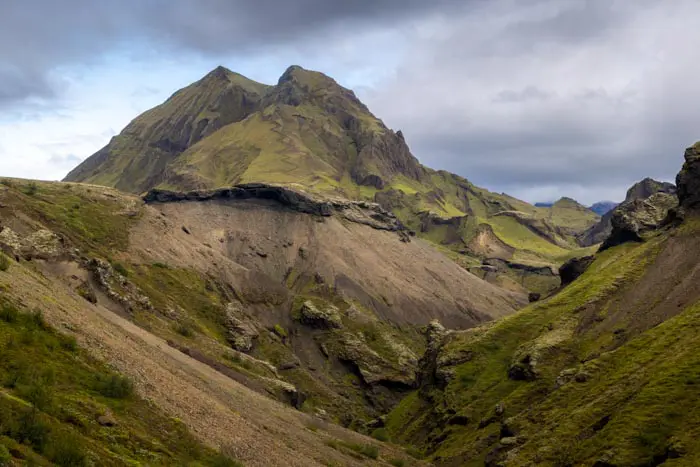
The hike to the summit of Rjúpnafell begins in Thórsmörk (the Valley of Thor), named after the Norse god. Located between the ice caps of Mýrdalsjökull and Eyjafjallajökull in the highlands, this remote area is a favorite place for Icelanders and a true paradise for hikers. Sheltered from Atlantic winds, the valley has a surprisingly mild summer climate, which promotes lush vegetation, including numerous birch forests.
This hike follows the Tindfjöll circuit route and includes a detour to the majestic summit of Rjúpnafell, one of the steepest mountains in Thórsmörk. The summit of Rjúpnafell rewards hikers with a spectacular, unobstructed 360° panorama. Standing in front of these immense glaciers, the architects of these vibrantly colored valleys and canyons, makes you feel so tiny.
Remarks
Getting to Thórsmörk: I strongly recommend taking one of the bus companies to reach the region. The F249 road to Thórsmörk has some of the most challenging river crossings in Iceland and should only be attempted by highly experienced drivers with suitable vehicles.
You can book tickets with the bus companies Icelandia and TREX.
Hiking in Thórsmörk: Check out my Thórsmörk hiking guide to help you choose your hikes.
Difficulties of the hike
This hike follows the Tindfjöll circuit route with a detour to the majestic summit of Rjúpnafell. The trail is clearly marked throughout. However, I strongly advise against attempting to climb Rjúpnafell if you are not an experienced hiker or are afraid of heights. The slopes are extremely steep, and the slippery terrain requires constant vigilance. If you don't feel comfortable, stick to the Tindfjöll circuit, which offers already breathtaking views.
What you'll love
- The exceptional summit panorama: The summit of Rjúpnafell offers spectacular views of the Mýrdalsjökull and Eyjafjallajökull glaciers, impressive colorful glacial valleys, and the meandering Krossá River below.
- Unique rock formations : Discover the small Tröllakirkja cave, a rock formation whose name means "troll church."
- The sense of accomplishment you'll feel after climbing one of the steepest mountains in Thórsmörk, with few other hikers, even in high season.
Hike technical sheet
➡️ Hiking parameters
➡️ Hiking parameters
➡️ Hiking parameters
Map and elevation profile of the hike
Slideshow


")
")


Nearby hikes

Tindfjöll Circuit Hike
- Difficulty : Moderate
- Duration : 3 h 30
- Distance : 8.8 km
- Elevation gain : 380 m

Valahnúkur Hike
- Difficulty : Easy
- Duration : 1 h
- Distance : 2.4 km
- Elevation gain : 200 m

Móði and Magni Craters Hike
- Difficulty : Hard
- Duration : 7 h
- Distance : 16.2 km
- Elevation gain : 1100 m

Hvannárgil Hike
- Difficulty : Easy
- Duration : 2 h
- Distance : 4.9 km
- Elevation gain : 380 m
Map of the 10 closest hikes
Hikes to discover
Let chance guide your steps: discover a random selection of the best hikes in Iceland.

Thakgil Yellow Circuit Hike
- Difficulty : Hard
- Duration : 6 h
- Distance : 15.1 km
- Elevation gain : 770 m

Hengifoss Hike
- Difficulty : Easy
- Duration : 1 h 45
- Distance : 4.9 km
- Elevation gain : 300 m

Fimmvörðuháls Trek
- Difficulty : Very Hard
- Duration : 10 h
- Distance : 23.8 km
- Elevation gain : 1320 m
Cascades de Dynjandi

Ljótipollur Crater Hike
- Difficulty : Easy
- Duration : 1 h 30
- Distance : 4.4 km
- Elevation gain : 190 m
