
Lofoten Islands Hiking Guide – Trails & Practical Advice

- Map of Hiking Trails in the Lofoten Islands
- Brunakseltinden - Boat trip to turquoise fjords
- Helvete - Exceptional Panorama Away from the Crowds
- Hermannsdalstinden - The roof of Moskenesøya for seasoned hikers
- Himmeltindan - At the Summit of Vestvågøya
- Narvtinden - Twin Peaks above Lake Solbjønvatnet
- Kollfjellet - Off-trail adventure to an exceptional panorama
- List of hikes in the Lofoten Islands
The Lofoten Islands are an archipelago of mountainous islands of incomparable beauty, where jagged peaks plunge directly into the Arctic Ocean. Boasting dizzying peaks, pristine white-sand beaches and colourful fishing villages, these islands offer a spectacular setting that makes them an exceptional playground for hikers.
I have selected 34 hikes spread across the archipelago's five main islands: Moskenesøya, Flakstadøya, Vestvågøya, Austvågøya and Gimsøya. You'll discover routes suitable for all skill levels, from family-friendly strolls to demanding technical climbs.
Map of Hiking Trails in the Lofoten Islands
Iconic hikes

Reinebringen - Iconic view of the Lofoten Islands
Difficulty: Easy
Duration: 2 h 45
Distance: 5 km
Elevation gain: 480 m
This is the iconic hike of the Lofoten Islands and it fully lives up to its reputation. In under an hour and a half of climbing up a well-maintained stone staircase, you'll reach one of the archipelago's most beautiful viewpoints, offering a bird's-eye view of the village of Reine, its colourful fishermen's cabins and the turquoise waters of the Reinefjord. The effort-to-reward ratio is unbeatable.

Ryten and Kvalvika Beach - Panoramic summit and dream beach
Difficulty: Moderate
Duration: 4 h
Distance: 10.1 km
Elevation gain: 770 m
This hike combines the best of the Lofoten Islands: a panoramic summit and access to the magnificent Kvalvika Beach. From the Ryten summit, you can overlook the turquoise bay bordered by steep cliffs. The trail is well-maintained and accessible, with a few directional signs to help you find your way. It is an ideal spot for camping in the grassy dunes behind the beach.

Fløya and Djevelporten - 360° Panorama of Svolvær
Difficulty: Moderate
Duration: 3 h 30
Distance: 4 km
Elevation gain: 600 m
The Fløya hike is the most popular ascent in Svolvær and on the island of Austvågøya as a whole. This short but intense route offers an exceptional 360-degree panoramic views of Svolvær, the capital of the Lofoten Islands, the surrounding fjords and lakes, and the highest peaks on the island. The hike takes you past the famous Djevelporten (Devil's Gate), a rock wedged between two cliffs which is a popular photography spot.

Festvågtinden - Lookout over the village of Henningsvær
Difficulty: Moderate
Duration: 3 h
Distance: 3.3 km
Elevation gain: 530 m
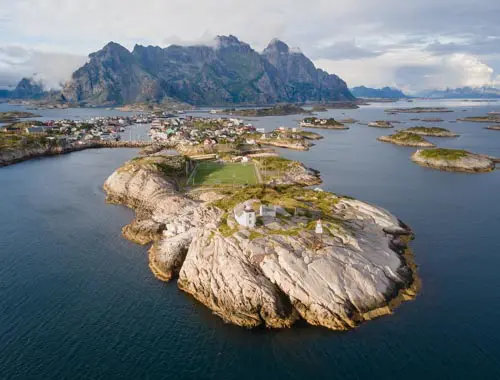
This 541-metre peak overlooks one of the archipelago's most beautiful sites and offers breathtaking views of the picturesque fishing village of Henningsvær and its islets. The climb is steep but without any technical difficulty and passes by the charming Heiavatnet lake halfway up. On a clear day, the panorama stretches all the way to the Vestfjord and the Norwegian mainland.
My favourite hikes

Brunakseltinden - Boat trip to turquoise fjords
Difficulty: Easy / Moderate
Duration: 3 h 30
Distance: 7.9 km
Elevation gain: 520 m
This hike is accessible only by boat from Reine and offers magnificent views along the entire route. At the summit, you'll discover an exceptional panorama with turquoise fjords on either side and the rugged peaks of Moskenesøya. The boat ride alone is worth the trip. You can also take a detour to the magnificent Bunes Beach, which is bordered by impressive cliffs, the perfect spot for camping or swimming in the icy waters.

Helvete - Exceptional Panorama Away from the Crowds
Difficulty: Hard
Duration: 5 h 30
Distance: 9.6 km
Elevation gain: 850 m
Far less crowded than the popular neighbouring Reinebringen, this challenging hike is rewarded with an even more spectacular panorama. The route traverses varied landscapes featuring waterfalls, alpine lakes and lush vegetation, before reaching the summit plateau. From the summit, you can take in the villages of Reine, the Kirkfjorden, Reinefjorden and Bunesfjorden fjords, as well as enjoying a panoramic view of the Moskenesøya island. A wild and authentic atmosphere is guaranteed.

Hermannsdalstinden - The roof of Moskenesøya for seasoned hikers
Difficulty: Very Hard
Duration: 10 h
Distance: 21.2 km
Elevation gain: 1810 m
The highest point on the island of Moskenesøya at 1,029 metres is reserved for well-trained hikers. This long and demanding ascent (over 20 km with 1,800 m of elevation gain) traverses diverse and absolutely magnificent landscapes. At the summit, you can truly dominate the island with exceptional views of the surrounding peaks, numerous high-altitude lakes and the fjords of Lofoten. It is a true alpine adventure in a wild and unspoilt setting. If you would prefer to break up the hike, the Munkebu huts offer an ideal campsite halfway up, with the added bonus of being able to climb the nearby Munken peak.

Himmeltindan - At the Summit of Vestvågøya
Difficulty: Moderate / Hard
Duration: 5 h
Distance: 7.7 km
Elevation gain: 950 m
This climb leads to the highest point on Vestvågøya, standing at 962 metres above sea level. Despite the steep and relentless slope, the trail presents no technical difficulties. At the summit, you can enjoy breathtaking views of the Haukland and Utakleiv beaches, the isolated peaks of western Vestvågøya, the Leknes plateau and the mountain ranges of northern Flakstadøya and Moskenesøya. This 360-degree panorama more than makes up for the effort.

Narvtinden - Twin Peaks above Lake Solbjønvatnet
Difficulty: Hard
Duration: 5 h
Distance: 6.9 km
Elevation gain: 850 m
This hike is significantly less crowded than other iconic peaks and leads to two distinct summits, offering exceptional panoramic views of the Selfjorden fjord and Stormarkpollen Bay. The magnificent Lake Solbjønvatnet accompanies you throughout the hike, reflecting the surrounding mountains spectacularly. From the very beginning of the hike, you can enjoy superb views of the lake and the Narvtinden summit from a small plateau. The route then gradually becomes more technical as you approach the summits.

Kollfjellet - Off-trail adventure to an exceptional panorama
Difficulty: Hard
Duration: 3 h 30
Distance: 3.9 km
Elevation gain: 490 m
This small, 512-metre mountain is one of the least known hikes in Lofoten. The complete lack of a trail means that you will have to navigate your way through a dense birch forest. From the summit, you can enjoy breathtaking views of the turquoise Flakstadpollen Bay, a hidden photographic gem. This is an authentic adventure for hikers seeking exploration.
Planning your hiking trip to the Lofoten Islands


When is the best time to go hiking in the Lofoten Islands?
Low-altitude hikes (under 500 m): Trails are accessible from May to October, though there may be residual snow on north-facing slopes in May.
Mid-altitude hikes (500–1,000 m): the best time is from mid-June to September. Before mid-June, there is still snow on the peaks and certain sections may be risky (steep snow-covered slopes and frozen snowfields). After September, the first autumn snows make conditions more unpredictable.
Pros and cons by season
May–early June: Arctic spring
Pros: Very few tourists, lower accommodation rates, days getting longer quickly (midnight sun from late May onwards), the driest months and the first Arctic flowers.
Cons: Lingering snow at higher elevations, some accommodation and tourist services not yet open, freezing water temperatures.
Mid-June–July: Midnight Sun
Pros: The midnight sun phenomenon (from late May to mid-July) means the sun never sets, providing magical light at all hours and total flexibility for hiking. It is ideal for long days of walking or high-altitude bivouacs under constant golden light. Optimal mountain conditions mean that all routes are accessible.
Cons: The start of the peak tourist season (especially from July onwards), high accommodation prices and mosquitoes in low-altitude wetlands.
July–August: the high season
Advantages: Mildest temperatures (averaging around 13–14°C), the 'warmest' sea for swimming, all tourist services open and a summer atmosphere in the villages.
Disadvantages: Heavy crowds on popular hiking trails (Reinebringen, Kvalvika, Ryten, Fløya, etc.) — parking lots may be full and the trails may be crowded between 10 a.m. and 4 p.m. Tip: Choose a less popular route — there are plenty to choose from! Accommodation rates are at their highest, so booking several months in advance is essential.
September: A good compromise
Pros: Trails gradually clear out, magnificent autumn colours (tundra turning red and birch trees turning yellow), first Northern Lights visible as early as mid-September, accommodation rates dropping, superb autumn light for photography, temperatures still comfortable.
Disadvantages: Days are getting shorter rapidly (by about 1 hour per week), weather is more unpredictable with more rain, the first snowfall is possible at the end of the month at higher elevations and some accommodations begin to close.
October–April: Arctic winter
This period is reserved for winter activities such as ski touring and snowshoeing, as well as viewing the Northern Lights. Summer hiking is no longer possible due to snow, cold and darkness. The polar night lasts from early December to early January.
Adapting to the weather:
Regardless of the season, always check the forecast on the Norwegian weather service before setting out. The weather can change drastically in a matter of hours, even in summer.
My recommendation
The ideal time to explore the Lofoten Islands on foot is from mid-June to mid-August. This period offers the best conditions for fully enjoying the archipelago, with the exceptional phenomenon of the midnight sun providing magical light and total flexibility for planning your hiking days.
Although the most popular hikes can be busy in July and August, the archipelago has many magnificent trails that are less well-known, even at the height of summer. Check out the hikes featured on this site to discover these hidden gems and enjoy the solitude of the mountains.


Getting to and around the Lofoten Islands
Accessing the archipelago
By plane
The fastest option from France. Two airports serve the archipelago:
- Leknes (LKN): in the centre of Vestvågøya, ideal for exploring all the islands
- Svolvær (SVJ): north of Austvågøya, convenient for exploring the northern part of the archipelago
Classic itinerary: Paris → Oslo → Bodø → Leknes/Svolvær. Flights from Bodø to the Lofoten Islands are operated by Widerøe (a subsidiary of SAS).
By ferry
This is an excellent alternative, especially if you plan to rent a car on the mainland, which is often cheaper than on the Lofoten Islands.
Bodø–Moskenes ferry: three hours and 15 minutes, serving the southern part of the archipelago (Moskenesøya). Fare: 605 NOK (€55) per car in 2026, regardless of the number of passengers.
Skutvik–Svolvær ferry: 2 hours and 30 minutes, serving the northern part of the archipelago (Austvågøya). Free for cars and pedestrians.
Both routes are operated by Torghatten.
Reservations: You can reserve a spot on the Bodø–Moskenes route (a 250 NOK surcharge per car in 2026), but this is not required as the company guarantees at least 50% of seats are available without a reservation directly at the port.
There are other options (Hurtigruten coastal express, etc.), but these are significantly more expensive and less frequent (one trip per day).
By car from the mainland
The archipelago is connected to the mainland by the E10 highway, which crosses the islands from north to south over 168 km (from Fiskebøl in the north to Å in the south). Access is via a bridge from Narvik in the north through a spectacular network of bridges and tunnels.
Getting around
Car: the most practical option
Unless you're planning a multi-day trek, a car is almost essential for hiking in the Lofoten Islands. Public transport is limited and poorly suited to hiking schedules. Car rentals are available locally, but book several months in advance during peak season (July–August), as availability is limited.
Important information for hikers:
- Parking spaces at popular hiking trailheads (Reinebringen, Kvalvika and Ryten) fill up very early during the high season
- Arrive before 8 a.m. or after 6 p.m. to find a spot


Where to stay in Lofoten?
Rorbuer: the iconic accommodation
A rorbu (plural: rorbuer) is a traditional type of accommodation in the Lofoten Islands. These traditional fishermen's cabins, which are often built on stilts by the sea and painted bright red, have been converted to accommodate tourists. They are the local equivalent of mountain huts, with comfort levels ranging from basic to relatively modern, depending on the establishment.
The rustic charm of these lodgings is more than offset by the beauty of their locations, which are often spectacular by the sea or a fjord, and by the authentic experience they offer. The most sought-after rorbuer are located in small villages such as Hamnøy, Sakrisøy, Reine or Å.
Estimated rates: 600–1,800 NOK (approx. €55–165) per night for a two-person rorbu, with significant variations depending on location, sea view and season.
Campgrounds and RV accommodations
The Lofoten Islands have numerous well-equipped campgrounds spread across the archipelago, which are ideal for travellers with tents, vans or RVs.
Estimated rates:
- Tent pitch: 200–300 NOK/night (approx. €18–27)
- Motorhome site with electricity: 300–400 NOK/night (approx. €27–37)
Wild camping: an economical option
Norwegian law grants the right of public access to nature (allemannsretten), which includes wild camping, but only if certain strict rules are followed.
Essential rules:
- At least 150 metres from residential areas
- A maximum of two consecutive nights in the same spot (longer if you're in the mountains or far from populated areas)
- Prohibited on cultivated or fenced-in land
- Absolute respect for nature (leave no trace)
- Stricter regulations at certain popular tourist sites
Norwegians place great importance on cleanliness and the environment. All rubbish must be taken with you and the site left in pristine condition.
Practical tips
Reservations: During the high season (mid-June to August), it is strongly recommended that you book your accommodation several months in advance, especially if you want a rorbu with an ocean view. In the off-season, there is more flexibility.
Overall budget: The cost of living in Norway is about 30% higher than in France. Plan for a substantial accommodation budget, or consider wild camping to keep costs down.
Base camp: If you have a car, you can drive across the archipelago from north to south in about three hours. There's no need to change accommodation every day — stick to one or two fixed bases. I particularly recommend the area around Ramberg, which is ideally located in the centre of the archipelago. There you'll find several campgrounds and rorbuer, close to some of the most beautiful hikes, which are concentrated on the island of Moskenesøya to the south.

Characteristics of the terrain
Don't be fooled by the modest elevations of the Lofoten peaks (rarely above 1,000 metres): hiking in the archipelago is far more demanding than it appears. The mountains rise directly from sea level, meaning every metre of elevation is earned through sheer leg strength, with no gradual warm-up on a valley trail. A hike considered 'easy' in the Lofoten Islands might be rated 'moderate' or even 'difficult' in other regions.
Lack of trail markings is the rule rather than the exception
The most striking feature of hiking in the Lofoten Islands is the near-total absence of trail markings. Of the 34 routes I tested, only two or three have proper trail markings. On most of the others, the trail remains visible thanks to repeated use by hikers, but you need to be able to read the terrain and ideally have a GPS track.
The terrain is varied and demanding
The slopes are often very steep, and the terrain frequently alternates between wet, slippery grass, rocks, marshy areas, unstable scree and smooth rock slabs. In rainy or foggy weather, certain sections can become dangerous as the sloping slabs turn into ice rinks.
Accessibility and options for all skill levels
Despite these challenges, the archipelago offers routes for all skill levels. For beginners or families, several hikes remain very accessible: Kvalvika Beach, Reinebringen (thanks to its Sherpa Stairs), Røren and Volandstinden, to name just a few.

Recommended gear
Due to the changeable nature of the Lofoten climate, thorough preparation is essential. You may encounter sun, rain, wind and even snow in a single day, regardless of the season. It is essential to check the weather forecast on the official Norwegian website before every mountain outing.
- Hiking boots: waterproof and high-cut, as the terrain is often wet and rocky
- Clothing: a layered system with a windproof and waterproof jacket, and warm clothing even in summer (high-altitude winds cause temperatures to drop)
- Navigation: GPS track of your route (trails are rarely marked)
- Hiking poles: particularly useful for the frequent steep descents in the archipelago
The main islands of Lofoten
The Lofoten Islands consist of four main islands, each offering distinct landscapes and hiking experiences. To explore the specific routes for each island, click directly on the island of your choice on the interactive map below.Geography and climate of the archipelago


Geographical location and topography
Location of the archipelago
The Lofoten Islands are remarkably situated:
- Latitude: between 67° and 69° North (170 km beyond the Arctic Circle)
- Distance from the mainland: approximately 50 km west of mainland Norway
- Length: 150 km from north to south
- Area: 1,227 km²
Main islands, from north to south: Austvågøya, Gimsøya, Vestvågøya, Flakstadøya, Moskenesøya, Værøy and Røstlandet.
| Demographic data | |
|---|---|
| Total population | ~24,000 inhabitants (2010) |
| Population density | 19 people/km² |
| Administrative capital | Svolvær |
Accessibility
Historically isolated by the rough waters of the Vestfjord, the archipelago has benefited from modern infrastructure since the early 2000s:
- Route E10 (Kong Olavs veg): a network of bridges and tunnels connecting the main islands to one another and to the mainland
- 3 airports with regular flights to the mainland
- Daily ferry service
Alpine landscapes by the ocean
The uniqueness of the Lofoten Islands lies in the combination of landscapes that are not typically found side by side. More than 70% of the archipelago consists of a mountain range with steep peaks, while the rest is divided between small plains in the centre (mainly on Vestvågøya) and in the north, and a narrow coastal strip where most of the population is concentrated.
This rare combination of natural environments makes the Lofoten Islands exceptional for hiking. In a single day's hike, you can start on a white-sand beach facing the Norwegian Sea, cross high-altitude pastures and ascend peaks that are still covered in snow, even in summer.


Climate
A mild oceanic climate despite the Arctic latitude
The Lofoten Islands are a remarkable climatic exception. Located more than 150 km north of the Arctic Circle, they enjoy a temperate oceanic climate thanks to the Gulf Stream and its extensions (the North Atlantic Drift and the Norwegian Current).
This maritime influence creates one of the world's greatest positive temperature anomalies relative to latitude: Røst and Værøy, in the southern part of the archipelago, are the northernmost places on Earth where average temperatures remain above 0 °C year-round.
Temperatures and precipitation in Svolvær
| Month | Temp. (°C) | Precip. (mm) |
|---|---|---|
| January | -1.5 | 159 |
| February | -1.8 | 134 |
| March | -0.3 | 112 |
| April | 2.2 | 88 |
| May | 6.5 | 63 |
| June | 10.1 | 67 |
| July | 13 | 87 |
| August | 13 | 94 |
| September | 9 | 146 |
| October | 5.2 | 210 |
| November | 1.8 | 160 |
| December | -0.5 | 180 |
| Annual | 4.7 | 1,500 |
Source: Meteorologisk institutt (1961–1990 averages)
May and June are the driest months, while October receives nearly three times as much precipitation as in the summer. Temperatures can exceptionally reach 30°C in July (the record being 30.4°C in Svolvær), and beautiful days reaching 25°C are not uncommon during the summer.
A capricious yet pleasant climate
The climate of the Lofoten Islands is similar to that of Brittany: sunny days with mild temperatures alternate with periods of cooler showers. In summer, stretches of seven consecutive days without rain are not uncommon. July and August offer the highest temperatures, while May and June are generally the driest months.
However, the weather remains changeable and unpredictable. The mountainous terrain and proximity to the ocean create microclimates: it can be sunny on the east coast while it rains just a few kilometres away on the west coast, and vice versa. Gear suitable for rain and cold is therefore essential for fully enjoying hiking, regardless of the season.


The Arctic Light Cycle
A unique natural spectacle
Located north of the Arctic Circle (68°N), the Lofoten archipelago experiences extreme variations in light throughout the year. This significantly influences the planning of hikes and your experience, depending on the time of year you choose to visit.
In summer, the archipelago enjoys the midnight sun: the sun remains visible 24 hours a day and never sets. In contrast, winter plunges the Lofoten Islands into polar night, a period during which the sun never rises above the horizon. Between these two extremes, the length of the days varies dramatically, increasing by about one hour per week in spring and decreasing by a similar amount in autumn.
Key periods in Leknes (centre of the archipelago)
Midnight sun: from 26 May to 17 July (24 hours of continuous daylight)
Polar night: from 7 December to 5 January (sun below the horizon)
Day length month by month
| Month | Date | Sunrise | Sunset | Day length |
|---|---|---|---|---|
| January | 1st | - | - | 0h (polar night) |
| 15 | 10:37 | 13:32 | 2h 55min | |
| February | 1st | 9:24 | 15:13 | 5h 49min |
| 15 | 8:22 | 16:17 | 7h 55min | |
| March | 1st | 7:21 | 17:14 | 9h 53min |
| 15 | 6:20 | 18:09 | 11h 49min | |
| April | 1st | 6:09 | 20:08 | 13h 59min |
| 15 | 5:07 | 21:03 | 15h 56min | |
| May | 1st | 3:55 | 22:09 | 18h 14min |
| 15 | 2:33 | 23:31 | 20h 58min | |
| 26 | - | - | 24h (midnight sun) | |
| June | Whole month | - | - | 24h (midnight sun) |
| July | 1st to 17th | - | - | 24h (midnight sun) |
| 20 | 2:26 | 23:57 | 21h 31min | |
| August | 1st | 3:23 | 23:00 | 19h 37min |
| 15 | 4:23 | 21:56 | 17h 33min | |
| September | 1st | 5:34 | 20:36 | 15h 02min |
| 15 | 6:21 | 19:40 | 13h 19min | |
| October | 1st | 7:21 | 18:28 | 11h 07min |
| 15 | 8:09 | 17:33 | 9h 24min | |
| November | 1st | 8:21 | 15:16 | 6h 55min |
| 15 | 9:19 | 14:20 | 5h 01min | |
| December | 1st | 10:48 | 13:00 | 2h 12min |
| 7 | - | - | 0h (polar night) |
Source: timeanddate.com – Data for Leknes (68.15°N, 13.61°E)
Impact on hike planning
Summer (June–July): Constant daylight allows for hiking at any hour, offering great flexibility to enjoy the most beautiful light and avoid peak times. Sunrises and sunsets blend into a long golden hour with the sun skimming the horizon.
Spring and autumn: The rapid increase in daylight hours (approximately 4 hours per month) provides excellent low-angle light for photography, and the Northern Lights can be seen as early as September.
Winter: The polar night does not mean total darkness. For several hours, a bluish twilight bathes the landscape, creating a unique atmosphere for winter hikes on snowshoes or cross-country skis. The Northern Lights are at their most active during this time.
List of hikes in the Lofoten Islands
| Name of the hike | Photo | ile | Difficulty | Duration | Length | Elevation gain | Popularity | My rating |
|---|