13-Day Hiking Road Trip in Iceland - Easy Level
This 13-day hiking road trip takes you through Iceland's incredible landscapes, with carefully selected hikes ranging from very easy to moderate, accessible to most hikers.
Your route i Click on a day to access its corresponding section. Then, click on the photos or titles to view detailed information about each hike.
- Day 1: Djúpalónssandur beach and three other sites
- Day 2: Thingvellir National Park and two other sites
- Day 3: Hveradalir geothermal area and two other sites
- Day 4: Ljótipollur crater and three other sites
- Day 5: Bláhnúkur - Brennisteinsalda
- Day 6: Rauðauga and Sveinstindur
- Day 7: Eldgjá canyon and Rauðibotn crater
- Day 8: Laki craters
- Day 9: Fjadrárgljúfur and two other sites
- Day 10: Múlagljúfur and three other sites
- Day 11: Vestrahorn, Stokksnes beach and Thakgil – purple trail
- Day 12: Skógá waterfall way and three other sites
- Day 13: Seljalandsfoss waterfall + Others
- Summary table
Practical Information
Summary of the 13-day hikes:
- Walking time: 39 hours
- Total elevation gain: 4,770 m
- Distance covered: 95.5 km
Any questions? Check out the Iceland FAQ.
Route
Your adventure begins with an exploration of the iconic sites of the west before diving into the heart of the unspoiled and raw territory of the Highlands for five days. You will conclude your journey with the wonders of southern Iceland, including spectacular places that remain relatively unknown.
Roads and Vehicle
This itinerary takes you along many F-roads, the tracks of the Icelandic Highlands where a 4x4 vehicle is mandatory. You will also cross several medium-sized rivers.
- A Dacia Duster or equivalent is recommended under normal conditions.
- Safety: See my dedicated page on driving in the Highlands.
Reservations and Accommodation
Before heading to Landmannalaugar on days four and five, remember to reserve your parking space.
For each stage, I suggest a place to spend the night:
- For camping or 4x4 camper vans: reservations are not usually necessary.
- For permanent accommodations: places are limited, so book in advance.
Flexible Itinerary
Fords
If you want to avoid fords, know that only days 6, 7, and 8 include them. After the Rauðauga hike on day six, you can return to paved roads by taking the F208 north.
Alternatives
Alternatives to replace the days in question:
- Extend your stay in Landmannalaugar, one of the most spectacular regions in the country.
- Take the bus to Thórsmörk, a hiker's paradise.
- Check out my detailed guides to hiking in Landmannalaugar and hiking in Thórsmörk to discover the best routes.
Need a different option?
Check out the Iceland hiking map to find nearby trails.
🗺️Detailed itinerary

Day 1: Djúpalónssandur Beach and Three Other Sites
Difficulty: Easy
Duration: 1 h 15
Distance: 3 km
Elevation gain: 130 m
On the first day of your adventure in Iceland, I invite you to explore the Snæfellsnes Peninsula. This natural gem does not require long hikes but is full of attractions and short walks that you cannot miss.
Your day will begin with a drive along a winding road through Berserkjahraun, a 4,000-year-old lava field surrounded by majestic volcanoes. Next, you will discover the famous Kirkjufell waterfall, one of Iceland's most iconic sites and one of the country's most photographed locations. This magical place, with Kirkjufell mountain in the background, offers spectacular views that will enchant you.
Then, you will walk along the majestic black sand beach of Djúpalónssandur. Renowned for its impressive rock formations, this beach is one of the most amazing places to explore in western Iceland. As you explore this unique beach, you will feel as if you have entered a fairy-tale world surrounded by striking volcanic landscapes and the remains of the Épine GY7 shipwreck.
To end the day, take a walk along the coastline of the fishing village of Arnarstapi. This picturesque village is a paradise for nature lovers, offering stunning views of steep cliffs populated by numerous species of seabirds.
Overnight: There are many options in the area.


Day 2: Thingvellir National Park and Two Other Sites
Difficulty: Very easy
Duration: 1 h 30
Distance: 5.1 km
Elevation gain: 80 m
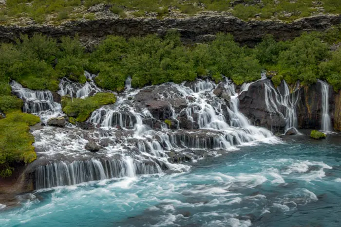
Start your day by discovering Hraunfossar, one of Iceland's most unique waterfalls. These fascinating cascades are formed by streams gushing out from under the Hallmundarhraun lava field. Hraunfossar stands out for its unparalleled charm and the turquoise hues of the river, revealing a spectacle of almost unreal beauty.
Next, continue your exploration with an immersion in Thingvellir National Park, one of Iceland's most iconic destinations. This exceptional site is listed as a UNESCO World Heritage Site and is of inestimable historical, cultural, and geological importance. Located in a rift valley, Thingvellir sits at the crest of the Mid-Atlantic Ridge, where the North American and Eurasian tectonic plates meet.
Finish your day by admiring the Brúarfoss waterfalls, which are renowned for their bright blue water.
Overnight: Camp or stay in a hotel between Brúarfoss and Geysir.


Day 3: Hveradalir Geothermal Area and Two Other Sites
Difficulty: Easy
Duration: 2 h
Distance: 4.3 km
Elevation gain: 320 m
Start your day with a visit to Geysir, one of Iceland's most iconic geothermal sites. Here, you can see Strokkur, a spectacular geyser that shoots a column of water up to 30 meters high every five to eight minutes.
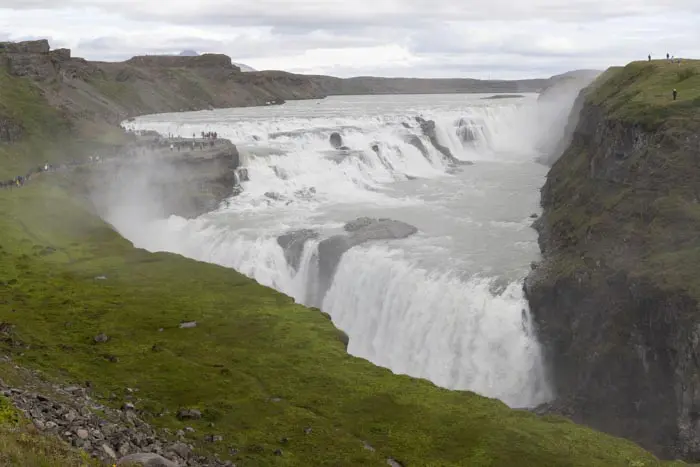
Next, visit the majestic Gullfoss waterfall. The force of the water crashing into the gorge below is sure to amaze you.
End this unforgettable day with a short hike to Hveradalir, one of Iceland's largest and most impressive geothermal areas. Nestled in the heart of the majestic Kerlingarfjöll mountain range, this region offers an extraordinarily rich natural spectacle. You will be fascinated by the site's vivid colors and geological diversity, including bubbling mud pools, steaming rivers, and mysterious fumaroles. It's a total immersion in one of the country's most captivating natural treasures.
Overnight: Spend the night camping or in a hotel in Kerlingarfjöll. After the hike, relax in the Kerlingarfjöll hot spring.


Day 4: Ljótipollur Crater and Three Other Sites
Difficulty: Easy
Duration: 1 h 30
Distance: 4.4 km
Elevation gain: 190 m
On the fourth day, prepare for a long drive to Landmannalaugar, nestled in the heart of the Icelandic Highlands. Along the way, you will be amazed by some of the most beautiful views of your trip and enjoy a short hike around the impressive Ljótipollur crater.
Your adventure begins with a visit to Háifoss Falls, Iceland's third-highest waterfall at 122 meters. Next, stop at Sigöldugljúfur Canyon, one of the country's hidden gems. Relatively unknown to tourists, this canyon is a true oasis in the middle of the Highlands with lush vegetation rarely found in this region.
Continue your exploration to Lake Bláhylur, located near Landmannalaugar. The landscape here is magnificent: the intense blue of the lake contrasts beautifully with the bright green moss of Mount Tjörvafell and the dark shades of the surrounding lava.
To end this day of discovery, hike around the Ljótipollur crater and lake, true gems of the Landmannalaugar region. Formed by a colossal eruption in 1477, this volcanic crater has gradually filled with water to create a spectacular lake in the heart of this unique landscape.
Overnight: Landmannalaugar campsite (days four and five).


Day 5: Bláhnúkur and Brennisteinsalda Hike
Difficulty: Moderate
Duration: 4 h
Distance: 9.9 km
Elevation gain: 620 m
This hike takes you into the heart of Landmannalaugar's most spectacular landscapes. It combines the most beautiful sections of the Bláhnúkur and Brennisteinsalda routes. These are two mountains and volcanoes emblematic of the region. This exceptional hike promises breathtaking views at every turn.
As you climb the two peaks, you will be rewarded with stunning vistas of lava fields, multicolored mountains, and the surrounding valleys. The region's vibrant colors and unique geological formations create a landscape of unparalleled beauty. At every turn, nature reveals its wonders, making this hike an unforgettable experience.
Overnight: Landmannalaugar campsite (days 4 and 5).

Day 6: Rauðauga Hike
Difficulty: Easy
Duration: 3 h 30
Distance: 9.2 km
Elevation gain: 340 m
The Rauðauga hike leads to one of Iceland's most fascinating natural wonders: the Red Eye, the mysterious source of the Rauðfossakvísl River. The water's high iron content has stained the riverbed and waterfalls a distinctive rusty red color.
This enchanting place, which is still largely unknown, is located in the heart of the Highlands, in the Fjallabak Nature Reserve. Here, you will discover Rauðfoss, an impressive 60-meter-high waterfall, cascades, and a red river winding through the landscape.

Sveinstindur Hike
Difficulty: Easy
Duration: 2 h
Distance: 3.5 km
Elevation gain: 420 m
To reach Langisjór, you will need to cross your first rivers in a 4x4. This experience will be repeated throughout the journey. The road is long but breathtakingly beautiful, giving you the impression that you are traveling in another world.
Once you arrive, you will enjoy a memorable hike to the 1,089-meter-high summit of Sveinstindur. Located in the heart of the Highlands, this peak stands alone in a vast black sand desert surrounded by green mountains. Ascending Sveinstindur offers spectacular views of Langisjór, and the isolation of this place makes the experience unparalleled. From the summit, you will be rewarded with one of the most sublime panoramas in Iceland—a breathtaking view that makes this hike absolutely unique.
Overnight: basic camping or Langisjór Lodge.

Day 7: Eldgjá Canyon Hike
Difficulty: Easy
Duration: 2 h
Distance: 5 km
Elevation gain: 200 m
Eldgjá, the Canyon of Fire, is part of a 40-kilometer-long chain of volcanic craters and fissures stretching northeast from the Katla volcano to the Vatnajökull ice cap. Eldgjá is an eight-kilometer-long gorge in the middle of this fissure. This gigantic fissure was formed by a colossal eruption around the year 939, one of the most significant eruptions of the past millennium.
In addition to marveling at the canyon, this tour invites you to discover the magnificent Ófærufoss waterfall. This multi-level waterfall stands out in the middle of this striking and desolate landscape.

Rauðibotn Crater Hike
Difficulty: Easy
Duration: 2 h 30
Distance: 6.8 km
Elevation gain: 280 m
The Rauðibotn crater is part of the Eldgja canyon, the largest volcanic canyon in the world. It was created by the colossal eruption of the Katla volcano in the 10th century. Rauðibotn means red bottom in Icelandic, referring to the bright red volcanic rock it is composed of. This creates a striking contrast with the yellow moss, the intense blue of the lake, and the Hólmsá river. This hike is a hidden gem of the Highlands, revealing wild and extraordinary landscapes.
Please note: To reach the start of the hike, do not take the F233, which your GPS will probably recommend. Although it is a shortcut, it involves crossing one of the most difficult rivers in Iceland. Instead, continue on the F208 until you reach the junction with the F210.
Overnight: Join Route 1 (Iceland's ring road) to reach civilization! You will find many campsites and hotels.

Day 8: Laki Craters Hike
Difficulty: Easy
Duration: 1 h 45
Distance: 3.2 km
Elevation gain: 260 m
Discover the Lakagígar, also known as the Laki craters. This series of 130 craters is aligned over 27 kilometers along a volcanic fissure on either side of Laki. These craters formed during the Skaftáreldar eruption in 1783, the fires of Skaftá, which spewed 14 cubic kilometers of lava over eight months.
From the 812-meter-high summit of Laki, you can admire this line of craters against the backdrop of the vast Vatnajökull ice cap, creating a magnificent and moving landscape. If you are lucky enough to visit after a few days of rain, the moss covering the lava fields will be bright yellow, creating a striking contrast with the black lava.
After your hike, take the F207 track to continue exploring the region's incredible landscapes. This road will allow you to discover other impressive craters and spectacular viewpoints.
Overnight: camping or lodge in Lakagigar.

Day 9: Fjaðrárgljúfur Canyon and Two Other Sites
Difficulty: Very easy
Duration: 1 h
Distance: 2.2 km
Elevation gain: 70 m
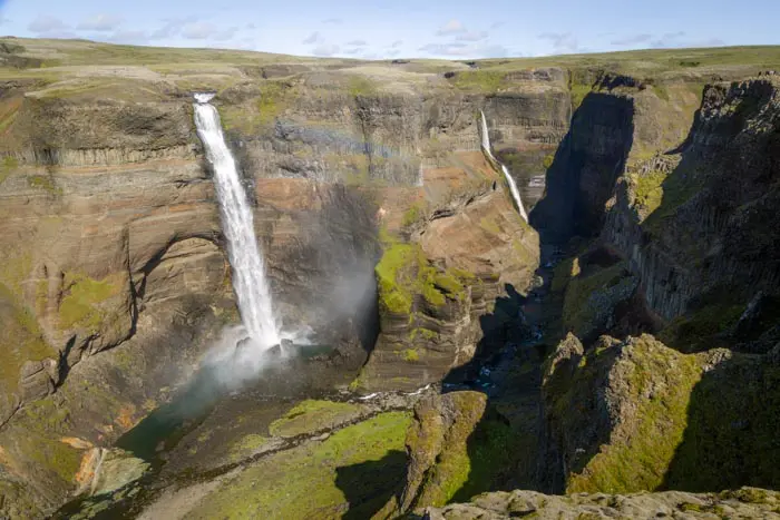
Start the day off right by exploring Fjaðrárgljúfur Canyon, a true natural wonder carved out about 10,000 years ago at the end of the Ice Age. This spectacular canyon stretches for two kilometers and reaches heights of up to 100 meters, offering breathtaking scenery. At the end of your walk, an observation deck awaits, revealing a stunning view of one of the site's most spectacular spots, including the picturesque Mögárfoss waterfall.
Continue your adventure with a short walk through Vatnajökull National Park to the Svartifoss waterfall. This waterfall, which is fed by meltwater from the Svinafellsjökull glacier and is very popular with visitors, plunges 20 meters down a cliff adorned with tall black hexagonal basalt columns, creating a striking contrast.
Finish your day with a visit to Svínafell Glacier, one of the many glacier tongues flowing from Vatnajökull, Europe's largest ice cap. Vatnajökull covers 11% of Iceland's surface area. This impressive glacier is eight kilometers long and 800 meters wide. A short trail will take you close to the glacier and its lake dotted with small icebergs for an unforgettable experience in Icelandic nature.
Overnight: There are numerous campsites and hotels in the area.


Day 10: Múlagljúfur Canyon and Three Other Sites
Difficulty: Easy
Duration: 2 h 15
Distance: 5.6 km
Elevation gain: 440 m
Múlagljúfur Canyon is a must-see destination in southeastern Iceland. Located near the famous Fjallsárlón and Jökulsárlón glaciers, this natural wonder was a well-kept secret among locals until the early 2020s. However, its popularity continues to grow, and it is poised to become a major attraction in the coming years. Take advantage of this opportunity to explore this exceptional place now!
At the heart of this narrow, spectacular canyon are the majestic Hangafoss and Múlafossur waterfalls. At 123 meters high, Hangárfoss is one of the tallest waterfalls in Iceland and offers a breathtaking spectacle.
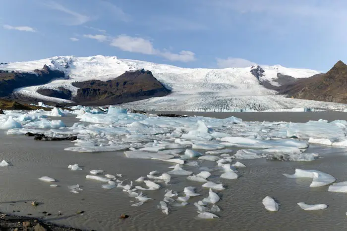
In the afternoon, set off to discover the lagoons of Fjallsárlón and Jökulsárlón, true natural wonders. These lakes are filled with icebergs that break off from the surrounding glaciers, creating a constantly changing display of ice sculptures. The imposing Vatnajökull ice cap in the background adds a grandiose dimension to this enchanting landscape.
Finally, let Diamond Beach enchant you. This unique stretch of black sand is home to sparkling icebergs. It gets its evocative name from the icebergs of all sizes that wash up on the beach and sparkle like diamonds in the sunlight. This magnificent yet ephemeral spectacle transforms the beach completely every day. The natural ice sculptures are constantly changing; some melt while new ones wash ashore.
Overnight: Camping or guesthouse at the Viking Café in Vestrahorn, your destination for the next morning. When you stay here, your entrance tickets to Stokksnes Beach are included, and you will have the opportunity to watch the sunset on this spectacular beach.


Day 11: Vestrahorn and Stokksnes beach
Vestrahorn is a majestic 454 meter-high mountain in southeastern Iceland. Although its height is moderate, its steep slopes and distinctive silhouette make it spectacular. It overlooks the magnificent black sand beach of Stokksnes, bordered by lush green dunes.
Although relatively popular, it remains far less touristy than the main sites of the Golden Circle, probably due to its remoteness from the capital. Yet it's only an hour's drive from the famous Jökulsárlón Lagoon. Stokksnes beach is particularly popular with photographers, with the reflection of Vestrahorn in the bay and the dunes contrasting beautifully with the black sand.
Between the café and the beach, you can also visit a Viking village that was reconstructed for the purposes of a movie- which, funnily enough, was never actually filmed! The bay is also known for attracting many seals, which you can observe on your nearby walks.

Thakgil Purple Circuit Hike
Difficulty: Moderate
Duration: 4 h 30
Distance: 11.2 km
Elevation gain: 480 m
Thakgil has a mystical atmosphere reminiscent of the enchanting scenery of Thórsmörk. This unique site is distinguished by its gorges and canyons with vertiginous walls covered in green moss, which contrasts beautifully with the intense black of the volcanic rocks.
This hike offers stunning vistas, including the Mýrdalsjökull ice cap and its Kötlujökull and Huldujökull glaciers.
Overnight: camp or stay in a lodge in Thakgil.

Day 12: Skógá Waterfall Way and Three Other Sites
Difficulty: Moderate
Duration: 5 h 30
Distance: 15.7 km
Elevation gain: 650 m
Start your day with a visit to Reynisfjara Beach, often considered the most beautiful beach in Iceland. Popular with visitors, this vast black sand beach dotted with pebbles is bordered by the imposing Reynisfjall basalt cliffs. At the foot of these cliffs, explore several caves and admire the perfectly geometric basalt columns that create a unique and fascinating landscape.
Next, discover Kvernufoss waterfall, one of Iceland's hidden treasures despite being only one kilometer from the popular Skógafoss waterfall. At 30 meters high, Kvernufoss plunges into a narrow gorge where the Kverna River winds its way, offering an intimate and picturesque setting far from the crowds.
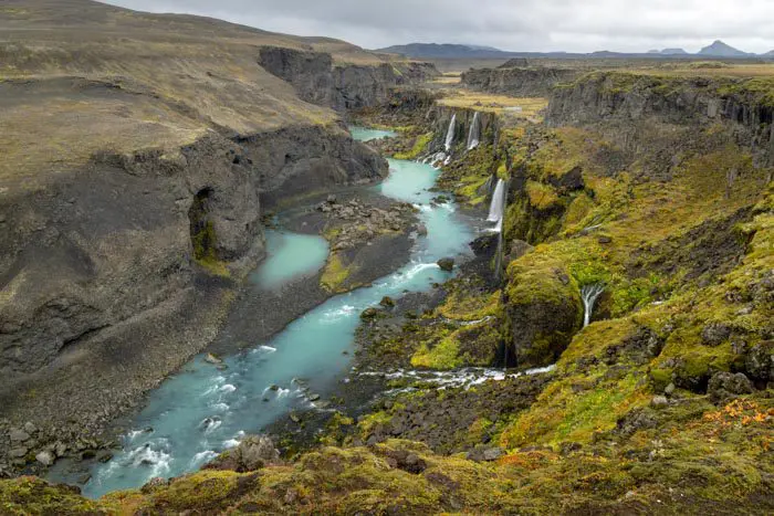
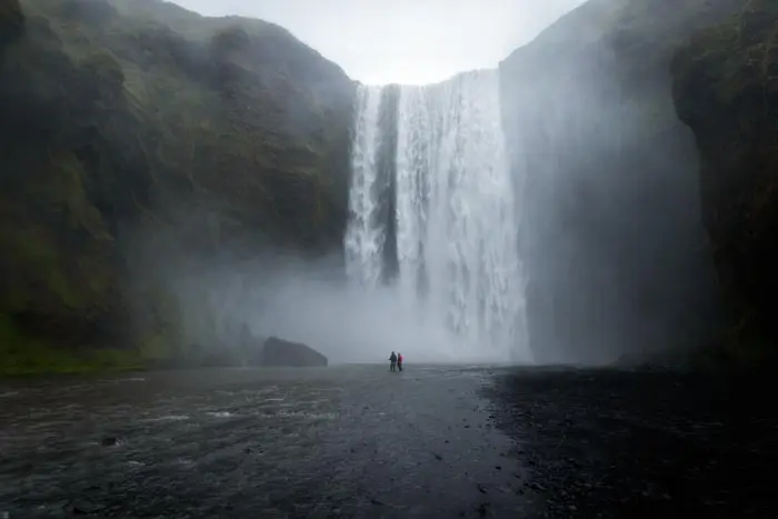
In the afternoon, set off on a hike along the Skógá Waterfall Way. The route starts at Skógafoss, one of Iceland's most iconic waterfalls, and immediately offers spectacular views. The trail then takes you away from the crowds to experience the tranquility and wild beauty of Iceland's landscapes.
Following the Skógá River, which originates from the Eyjafjallajökull and Mýrdalsjökull glaciers, the trail winds through a landscape dotted with over twenty waterfalls. If the entire route seems too long, you can choose to hike only part of it. See the hike detailed sheet for more details.
Overnight: camp or stay in a hotel in Skógar.


Day 13: Seljalandsfoss Waterfall and More
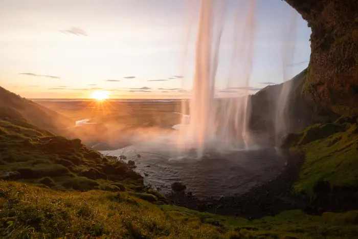
On your last day, start with a visit to Seljalandsfoss, a majestic 60-meter-high waterfall. What makes Seljalandsfoss unique is the opportunity to admire it from all angles. The cliffs behind the falls shelter a vast cavern, and a footpath allows you to walk all the way around the waterfall.
Then, head west to Reykjavik, Iceland's vibrant capital, or relax at one of the region's iconic locations: the Blue Lagoon, a famous geothermal spa on the Reykjanes Peninsula; or the Reykjadalur thermal river.
📋Summary table
| Name of the hike | Photo | Activity | Difficulty | Duration | Length | Elevation gain | Popularity | My rating |
|---|