14-Day Hiking Road Trip in Corsica - North to South
This 14-day hiking road trip takes you through Corsica's diverse and spectacular landscapes, with carefully selected hikes that reveal the island's full richness from coast to mountains.
Your route i Click on a day to access its corresponding section. Then, click on the photos or titles to view detailed information about each hike.
- Day 1: Capo Pertusato and Bonifacio
- Day 2: Monacia d'Aullène and Sentier des Bruzzi
- Day 3: Southeast beaches
- Day 4: Aiguilles de Bavella
- Day 5: Purcaraccia waterfall
- Day 6: Monte Renoso
- Day 7: Lakes of Melo and Capitello
- Day 8: Lac de Nino
- Day 9: Capu a Cuccula
- Day 10: Capu d'Orto
- Day 11: Girolata via punta di a Literniccia
- Day 12: Ruins of Occi and Pigna - Sant'Antonino
- Day 13: Monte Cinto
- Day 14: Lotu and Saleccia beaches
- Summary table
Practical Information
Summary of the 14-day hike:
- Walking time: 61 hours, 15 minutes
- Total elevation gain: 8,760 m
- Distance covered: 136.2 km
Any questions? See the Corsica FAQ.
A varied and flexible itinerary
Diversity of experiences: This itinerary has been designed to offer a rich variety of experiences. Along the way, you will discover:
- Authentic Corsican towns and villages
- Majestic lakes and peaks
- Idyllic beaches
- Waterfalls and natural pools
- And much more!
Adaptability: To ensure that everyone can enjoy the trip to the fullest, alternatives are offered on the most demanding stages. Whether you are a beginner or an experienced hiker, you will find routes adapted to your abilities and the conditions you encounter.
Direction of the itinerary
Choose the south-to-north route for a smooth progression. The most technical hikes in the center and northwest will thus take place in the second week, after a period of acclimatization.
Need a different option?
Check out the map of hikes in Corsica to discover nearby routes.
🗺️Detailed itinerary

Day 1: Capo Pertusato and Bonifacio
Difficulty: Easy
Duration: 3 h 30
Distance: 9.1 km
Elevation gain: 280 m
Set off today to explore the southernmost point of Corsica: Capo Pertusato. This unforgettable hike from Bonifacio takes you along the Accore Coast, where majestic white limestone cliffs plunge into the Mediterranean Sea. Along the way, enjoy spectacular views of the fortified citadel perched atop its vertiginous cliffs.
On your way back, stroll through the cobbled streets of the old town, explore the lively port, and experience the authentic charm of this historic city.

Day 2: Monacia-d'Aullène Hike
Difficulty: Easy
Duration: 3 h 15
Distance: 6.9 km
Elevation gain: 360 m
In the morning, set off to explore the heritage trail of Monacia d'Aullène and take a journey back to the Mesolithic era. Discover the fascinating orii, cave dwellings carved into tafoni—natural cavities formed by wind erosion in the granite.
These ancient sites have had many uses over the centuries, including as homes, warehouses, and burial sites, and they bear witness to Corsica's rich past.

Bruzzi Trail Hike
Difficulty: Easy
Duration: 2 h
Distance: 5 km
Elevation gain: 200 m
In the afternoon, walk along the Bruzzi trail from cove to cove along the coastline. You will be amazed by the diversity of the evocatively shaped tafoni, and you will have the opportunity to relax on sandy beaches, including the famous Coral Beach.
Alternatively: For a hike of similar difficulty, you can opt for the Lion of Roccapina. If you are looking for a more challenging mountain hike, the ascent of the Uomo di Cagna will offer spectacular views.

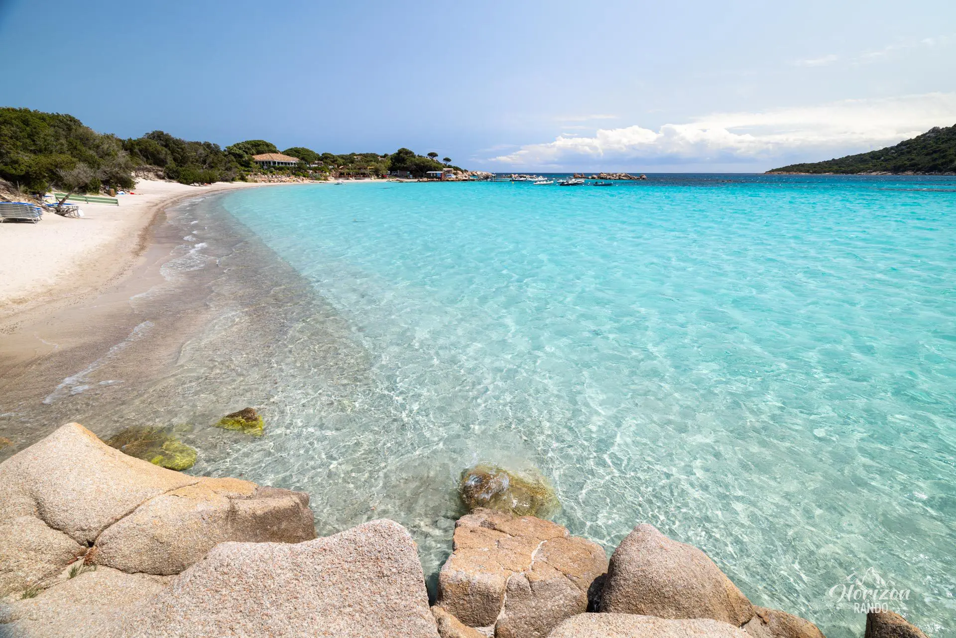
Day 3: Sperone Beaches Hike
Difficulty: Very easy
Duration: 1 h 15
Distance: 3.2 km
Elevation gain: 70 m
This day is more peaceful with no hiking on the agenda. It is entirely dedicated to discovering the sublime beaches of southwestern Corsica. Begin with the two beaches of Petit Sperone and Grand Sperone, which border the magnificent turquoise Piantarella lagoon with its crystal-clear waters.
Then, continue at your leisure to the perfectly shell-shaped Bay of Rondinara and on to the famous beaches of Santa Giulia and Palombaggia, which are renowned for their pristine white sand and umbrella pines.


Day 4: Bavella needles Hike
Difficulty: Hard
Duration: 5 h 30
Distance: 11.4 km
Elevation gain: 890 m
For your first day in the Corsican mountains, head for the Col de Bavella, often considered the most spectacular pass on the island. The Aiguilles de Bavella form an impressive massif of pinnacles carved out of pink granite, dominating the landscape with their jagged silhouettes. This hike, which is relatively technical in places, offers breathtaking views throughout the ascent, where you will feel tiny in front of these immense granite towers.
Alternatives: Also from the Bavella Pass, the Trou de la Bombe hike is less spectacular but accessible to all levels. The same goes for the charming Plateau du Coscione, with its green pozzines and bucolic atmosphere.

Day 5: Purcaraccia Waterfalls Hike
Difficulty: Moderate
Duration: 2 h 30
Distance: 3.7 km
Elevation gain: 230 m
An absolutely fabulous site in the heart of the Aiguilles de Bavella massif. Here you will discover a breathtaking natural spectacle: numerous turquoise water basins connected by waterfalls and natural slides, all set against a backdrop of magnificent granite cliffs. The site's popularity in high season means it is best to go early in the morning to fully enjoy the magic of the place in peace and quiet.
Just a few kilometers away, on the road to the Bavella Pass, you can also discover the Polischellu Waterfalls.

Day 6: Monte Renoso Hike
Difficulty: Moderate
Duration: 3 h 45
Distance: 7.9 km
Elevation gain: 660 m
Prepare for an unforgettable hike to the 2,352-meter summit of Monte Renoso. Due to the high starting point of the small Capannelle-Ghisoni ski resort, which sits at an elevation of over 1,600 meters, the elevation gain on this hike is relatively low. This makes Monte Renoso one of the most accessible 2,000-meter peaks in Corsica.
At the summit, you will be rewarded with an exceptional 360° panorama. On a clear day, you can see the Mediterranean Sea to the east and west, as well as the great peaks of central Corsica. The route passes through magnificent landscapes, including the green pozzines of the Pizzolo stream and the stunning Lake Bastani.

Day 7: Melo and Capitello Lakes Hike
Difficulty: Moderate
Duration: 3 h 30
Distance: 6.6 km
Elevation gain: 560 m
This magnificent hike in the famous Restonica Valley is one of the most iconic in Corsica. The splendid lakes of Melo and Capitello, surrounded by impressive peaks and cliffs, are of glacial origin and remain frozen for six months of the year.
Alternatives: Of similar difficulty, the Lakes Rinoso or Lake Oriente offer more tranquility. More demanding, the summit of A Maniccia will delight lovers of alpine panoramas. Finally, the ascent of Monte Rotondo, Corsica's second highest peak, is reserved for experienced hikers.

Day 8: Nino Lake Hike
Difficulty: Moderate
Duration: 4 h 30
Distance: 9.9 km
Elevation gain: 720 m
The Nino Lake hike takes you to one of Corsica's natural wonders. Located at an altitude of 1,743 meters on the Camputile plateau, the lake is surrounded by numerous pozzines, small peat bogs dotted with interconnected water holes. The lake is the source of the Tavignanu, the second longest river on the island.
The hike begins with a walk through the magnificent Valdu Niellu forest, shaded by Laricio pines. Then, the route becomes more technical as it climbs toward Bocca a Stazzona. There, you can admire a magnificent panorama of Lake Nino with the Rotondo massif in the background. This route is very popular with hikers and offers a unique natural spectacle: horses and cows grazing freely in an exceptional setting.

Day 9: Capu a Cuccula Hike
Difficulty: Moderate
Duration: 3 h 45
Distance: 6.3 km
Elevation gain: 650 m
This little-used trail starts at the Col de Vergio and offers exceptional views of the legendary peaks of Paglia Orba and Capu Tafunato to the north, while to the west lies the sublime Gulf of Porto.
Alternatives: If you want to extend the day or are looking for a more accessible option, the Radule Waterfall and the Aitone Waterfalls are two easy walks to refreshing natural pools. Conversely, for a major challenge, the ascent of Paglia Orba, nicknamed the "Corsican Matterhorn," will be an unforgettable adventure reserved for seasoned hikers.

Day 10: Capu d'Orto Hike
Difficulty: Moderate
Duration: 5 h
Distance: 11 km
Elevation gain: 860 m
The road leading to the start of this hike passes through the magnificent Calanques de Piana, a UNESCO World Heritage Site and undoubtedly one of the most beautiful roads on the island. The summit of Capu d'Orto offers breathtaking views: in the foreground stand the impressive granite peaks of the "Tre Signore," while in the background, the turquoise waters of the Gulf of Porto stretch out on one side and the peaks of the Cinto massif on the other.
Alternatives: Capo Rosso is a more accessible option that also offers superb views of the Gulf of Porto. The nearby summit of Capu di u Vitullu is similar in difficulty to Capu d'Orto but is much less crowded, making it ideal for those who enjoy peace and quiet.

Day 11: Girolata via Punta di a Literniccia Hike
Difficulty: Hard
Duration: 6 h 30
Distance: 14.4 km
Elevation gain: 870 m
Discover this wonderful loop trail leading to the charming fishing village of Girolata via Punta di a Literniccia. You will enjoy spectacular views of the Scandola Nature Reserve, a UNESCO World Heritage Site, and the Gulf of Girolata.
Alternatives: The Girolata hike via the postman's trail is a more accessible option and the most direct way to reach the village. However, this route is much busier and offers less varied landscapes. Nearby, the hike to the summit of Monte Senino is a shorter but more technical alternative, revealing a magnificent panorama of the Gulf of Porto.

Day 12: Occi Ruins Hike
Difficulty: Easy
Duration: 2 h
Distance: 4.8 km
Elevation gain: 310 m
The Occi Ruins hike takes you to an abandoned 14th-century village perched 380 meters above sea level in Lumio, Balagne. This easy, family-friendly hike follows an old mule track and offers spectacular views of the Gulf of Calvi, Algajo Bay, and Sant'Ambrogio Marina. Once there, you will find about twenty ruined houses and the fully restored Annunziata Chapel.

Pigna and Sant'Antonino Hike
Difficulty: Easy
Duration: 2 h 15
Distance: 5.2 km
Elevation gain: 300 m
This circular hike connects two of the most beautiful villages in Balagne: Pigna and Sant'Antonino. It passes by the Saint-Dominique convent in Corbara. Pigna, a village of artists with blue shutters, and Sant'Antonino, perched at an altitude of 500 meters on its granite peak and ranked among the most beautiful villages in France, offer remarkable panoramic views of the Aregno plain, the surrounding mountains, and the Mediterranean Sea.
This itinerary combines cultural discovery with typical Balagne landscapes, including ancient mule tracks, olive groves, and a rich architectural heritage.

Day 13: Monte Cinto Hike
Difficulty: Hard
Duration: 8 h
Distance: 11.8 km
Elevation gain: 1520 m
As your stay draws to a close, you will be perfectly prepared to undertake the ascent of Monte Cinto, Corsica's highest peak at 2,706 meters. This demanding hike rewards your efforts with spectacular views along the way and a 360° panorama once you reach the summit, taking in the entire island from the sea to the mountains. The road leading to the village of Haut-Asco, the starting point of the route, already passes through magnificent high mountain landscapes.
Alternative: The hike to the summit of A Muvrella, also from Haut-Asco, is significantly shorter but still relatively technical.

Day 14: Lotu and Saleccia Beaches Hike
Difficulty: Easy to Hard
Duration: 7 h 30
Distance: 27.3 km
Elevation gain: 320 m
On this last day, there is only one destination but several options are available, depending on how much time you have and your fitness level after days of hiking. Refer to the hike information sheet to select the option that best suits you, ranging from an easy stroll to a challenging hike.
No matter which option you choose, you will discover two white sand paradises: Lotu beach and Saleccia beach, located near Saint-Florent. The kilometer-long Saleccia beach with its turquoise waters is renowned as one of the most beautiful on the island. Accessible only by boat or on foot, these beaches escape excessive tourist crowds. The path to the beaches reveals sublime landscapes and several coves that invite you to take a dip.
📋Summary table
| Name of the hike | Photo | Difficulty | Duration | Length | Elevation gain | Popularity | My rating |
|---|