

Håen Hike
Hike overview
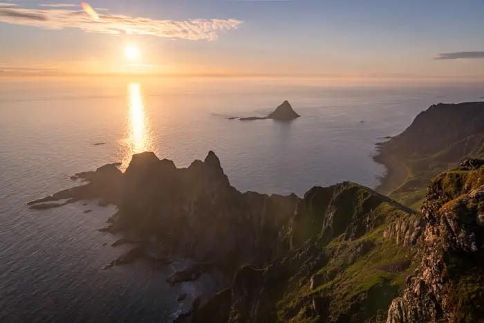
Perched at an elevation of 438 meters on the island of Værøy, at the southernmost tip of the Lofoten archipelago, the Håen summit (also known as Håheia) is one of the most beautiful viewpoints in the archipelago. The short, relatively easy loop offers a succession of panoramic views, including a balcony trail and a wide, open, grassy ridge. The highlight is the bird's-eye view of secluded Måstad Bay and the abandoned village of the same name. The atmosphere feels like the end of the world.
This hike is magnificent and varied—provided you choose the right route. Most hikers follow the old military road on both the way there and back, which robs the hike of much of its appeal. The route described here, on the other hand, takes you along trails to viewpoints bypassed by the military road.
Remarks
Access to the island: Værøy is only accessible by ferry, which departs from Moskenes or Bodø. Check the schedules on the Torghatten website. The crossing takes about an hour and a quarter, with one or two departures per day. For reference, the crossing was free in 2026.
Parking: there is a small, free parking lot with about ten spaces at the bottom of the valley, north of Sørland. The military road leading to the summit is closed to public traffic.
Best time to visit: generally from mid-May to mid-October. See the Norway FAQ for more details.Direction of the loop: walking counterclockwise is recommended to preserve the element of surprise at the main viewpoint and to simplify navigation.
Extensions: depending on your preferred route, you can download two GPX files: Håen and its extensions—the classic loop plus the detour to the plateau (marker 3) and the descent via the trail (marker 4); Håen and Hornet—both peaks in the same loop, including the extensions mentioned above.
Difficulties and description of the hike
The trail is not marked, and the few signs at intersections mainly point toward the military road. It's best to have the GPX track, especially in the lower section of the return leg, where the path becomes faint.
From the small parking lot, the trail climbs northwest up a fairly steep slope—though without any technical difficulty—over classic dirt-and-stone terrain to the pass between Hornet and Håen. At this point, the optional detour to the summit of Hornet (marker 1, shown by the blue dashed line on the map) rejoins the main route. The rest of the route follows a pleasant, gently ascending, balcony-like trail and then a wide, grassy ridge that offers sweeping views on both sides, notably of the Lofoten Islands (Moskenesøya) in the distance.
You will then reach the Håen lookout (marker 2), located just behind the radar dome of the former NATO station. The view is absolutely breathtaking as you suddenly take in the entire western part of Værøy Island, Måstad Bay, the white-sand beaches below, and the cliffs of Måhornet rising behind the deserted village.
The return trip follows a grassy trail that descends gently. There is an easy optional detour that I highly recommend. It leads to a small plateau (marker 3, marked by a blue dotted line) that offers superb views of Sørland on one side and Måstad Bay on the other. The descent continues to marker 4, where you have two options. You can follow the old military road for a few hundred meters before rejoining the outbound trail (the default option for the GPX button, suitable for most hikers). Or, you can stay on the narrow path (marked by a blue dotted line). This path is steeper, rougher, and sometimes hard to spot. However, it avoids any road sections, and is not a problem with the GPX track and a little experience.
What you'll love
- The Håen viewpoint, one of the most spectacular in the Lofoten Islands. It offers a bird's-eye view of wild Måstad Bay, which is surrounded by steep cliffs.
- The secondary viewpoints along the ridge and on the way back, such as the plateau at marker 3, which most hikers miss by staying on the road.
- The "end-of-the-world" atmosphere overlooking Måstad, a former fishing and seabird hunting hamlet, abandoned in the 1970s.
Hike technical sheet


➡️ Hiking parameters

➡️ Hiking parameters


➡️ Hiking parameters


Map and elevation profile of the hike
Slideshow


Nearby hikes

Hermannsdalstinden Hike
- Difficulty : Very Hard
- Duration : 10 h
- Distance : 21.2 km
- Elevation gain : 1810 m

Munken Hike
- Difficulty : Hard
- Duration : 5 h 30
- Distance : 13 km
- Elevation gain : 1030 m

Reinebringen Hike
- Difficulty : Easy
- Duration : 2 h 45
- Distance : 5 km
- Elevation gain : 480 m

Helvete Hike
- Difficulty : Hard
- Duration : 5 h 30
- Distance : 9.6 km
- Elevation gain : 850 m
Map of the 10 closest hikes
Hikes to discover
Let chance guide your steps: discover a random selection of the best hikes in Norway.

Grytetippen and Keipen Hike
- Difficulty : Hard
- Duration : 6 h
- Distance : 9.6 km
- Elevation gain : 1140 m

Raudmelen Hike
- Difficulty : Moderate
- Duration : 5 h
- Distance : 9.8 km
- Elevation gain : 920 m

Himmeltindan Hike
- Difficulty : Moderate / Hard
- Duration : 5 h
- Distance : 7.7 km
- Elevation gain : 950 m
Måtinden Hike
- Difficulty : Moderate
- Duration : 3 h
- Distance : 8 km
- Elevation gain : 520 m

Saksa Hike
- Difficulty : Hard
- Duration : 5 h
- Distance : 6.8 km
- Elevation gain : 990 m

Briksdalsbreen Hike
- Difficulty : Easy
- Duration : 1 h 45
- Distance : 4.7 km
- Elevation gain : 180 m