
Passo Pordoi to Lago di Fedaia via Viel del Pan Hike
Hike overview
The hike from Passo Pordoi to Lago di Fedaia follows the historic Viel del Pan trail, also known as the "bread trail" in Ladin, a Romance language spoken in the Dolomites. This was the former trade route used by flour merchants between the Belluno region and Val di Fassa.
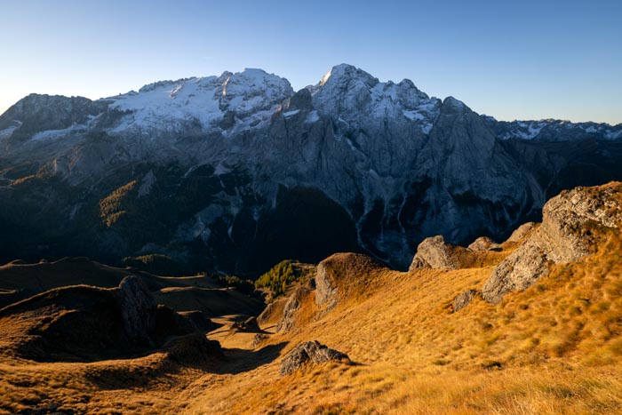
Restored in the early 20th century by German mountaineer Karl Bindel (hence its other name, Bindelweg), the route is now one of the most beautiful balcony trails in the Dolomites, facing the Marmolada and its glacier. The upper section is wide and easy to walk, making it very popular. It becomes wilder and more committing on the final descent toward the lake.
Remarks
Short version: the out-and-back from Passo Pordoi to Rifugio Viel dal Pan is about 7.5 km with 250 m of elevation gain and takes about 2 h 30. It's ideal for a half-day hike or a family outing since you won't have to tackle the steeper descent toward the lake — the balcony view of the Marmolada remains largely consistent, so you'll still enjoy most of the panorama.
Description and difficulties of the hike
From Passo Pordoi (2,239 m), Trail 601—which also corresponds to Alta Via 2—starts near the small chapel, just above the road. The ascent begins on a wide trail that circles around Sas Becé. You will pass by Rifugio Sass Becé first, and then Rifugio Fredarola (2,370 m), where the view of the Marmolada suddenly opens up.
From Fredarola, the balcony section begins: a wide, nearly flat mule track carved into steep meadows. Dark rock outcrops appear in places—a geological feature of the Padon range. Unlike the neighboring massifs, the Padon range is composed of black volcanic rock, not dolomite. The entire traverse offers a magnificent panorama: the north face of the Marmolada and its glacier directly ahead and Lago di Fedaia gradually coming into view below. This first section is wide and easy-going and presents no difficulty. It leads to the Rifugio Viel dal Pan (2,432 m), the highest point of the hike, in about 1 hour and 15 minutes.
Beyond the refuge, Trail 601 alternates between short ascents and descents before beginning its steep drop toward Lago di Fedaia. The slope steepens significantly in the final switchbacks over rocky terrain, punctuated by a few sections equipped with handlines and slightly exposed. You will reach the road alongside the lake (2,053 m), near Rifugio Marmolada and the dam.
The return trip follows the same route. To change up the end of the hike, you can also reach Passo Pordoi via the Padon ridge.
Waymarking is excellent: red-white-red marks typical of the Italian Alpine Club, signs at every intersection, and the trail number (601) consistently indicated.
What you'll love
- The uninterrupted panorama of the north face of the Marmolada, its glacier, and Lago di Fedaia below.
- The three mountain huts along the route (Fredarola, Viel dal Pan, and Marmolada) where you can stop for refreshments or take a break.
- The flexibility to customize your outing: an out-and-back to Rifugio Viel dal Pan for an easy family hike, or a more challenging return via the Padon ridge.
Hike technical sheet
➡️ Hiking parameters
➡️ Hiking parameters
➡️ Hiking parameters
Map and elevation profile of the hike
Slideshow


Nearby hikes
Padon Ridge and Viel del Pan Loop Hike
- Difficulty : Easy
- Duration : 2 h 45
- Distance : 7.4 km
- Elevation gain : 420 m

Piz Boè Hike
- Difficulty : Easy
- Duration : 2 h 45
- Distance : 6.3 km
- Elevation gain : 460 m

Piz Boè and Piz Selva Hike
- Difficulty : Hard
- Duration : 6 h 30
- Distance : 16.2 km
- Elevation gain : 930 m

Sassolungo Loop
- Difficulty : Moderate
- Duration : 5 h 30
- Distance : 16.1 km
- Elevation gain : 790 m
Map of the 10 closest hikes
Hikes to discover

Via Ferrata Ra Gusela and Averau
- Hiking Difficulty : Moderate
- Via Ferrata Difficulty : A/B (Easy)
- Duration : 4 h 30
- Distance : 9 km
- Elevation gain : 720 m

Lago Limides, Monte Nuvolau and Cinque Torri Circuit
- Difficulty : Moderate
- Duration : 4 h 30
- Distance : 11.1 km
- Elevation gain : 790 m

Via Ferrata Innerkofler - Monte Paterno
- Hiking Difficulty : Moderate
- Via Ferrata Difficulty : A/B (Easy)
- Duration : 4 h 30
- Distance : 9.5 km
- Elevation gain : 650 m

Fanes Waterfalls Hike and Via Ferrata
- Hiking Difficulty : Moderate
- Via Ferrata Difficulty : A (Easy)
- Duration : 4 h 30
- Distance : 10 km
- Elevation gain : 560 m

Monte Nuvolau, Monte Averau and Cinque Torri Circuit
- Hiking Difficulty : Hard
- Via Ferrata Difficulty : A/B (Easy)
- Duration : 5 h 30
- Distance : 11.4 km
- Elevation gain : 950 m

Via Ferrata Ra Gusela
- Hiking Difficulty : Easy
- Via Ferrata Difficulty : A (Easy)
- Duration : 3 h 30
- Distance : 8 km
- Elevation gain : 610 m