Padon Ridge and Viel del Pan Loop Hike
Hike overview
Cette boucle au départ du Passo Pordoi combine deux ambiances contrastées : une ascension sauvage et panoramique par les crêtes du Padon, puis un retour par le sentier-balcon du Viel del Pan, nettement plus fréquenté.
L'itinéraire débute par un belvédère remarquable, le Col del Cuc, avant de rejoindre le tracé historique du Viel del Pan — le « chemin du pain » en ladin (langue romane des Dolomites). C'était autrefois la route des marchands de farine entre la région de Belluno et le Val di Fassa. Restauré au début du XXe siècle par l'alpiniste allemand Karl Bindel (d'où son autre nom de Bindelweg), ce sentier est aujourd'hui l'un des plus beaux balcons des Dolomites, face au massif de la Marmolada et son glacier.
Remarks
À noter : au-delà du Col de Cuc, le sentier 636 se prolonge sur l'arête vers le Sass Ciapel et plus loin encore, mais devient nettement plus technique.
Description and difficulties of the hike
Du Passo Pordoi (2 239 m), suivre le sentier 601 qui démarre près de la petite chapelle, juste au-dessus de la route. La montée s'effectue d'abord sur une large piste contournant le Sas Becé. On dépasse successivement le Rifugio Sass Becé puis le Rifugio Fredarola (2 370 m), d'où la vue sur la Marmolada se dévoile d'un coup.
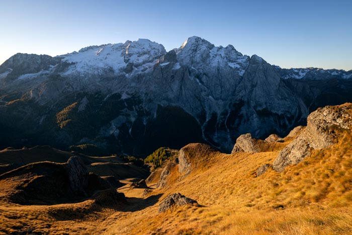
C'est ici que la boucle commence : à gauche du refuge, repérer le panneau du sentier 636 — Sentiero delle Creste del Padon — qui grimpe franchement vers le Col de Cuc (2 563 m), point culminant du parcours. C'est la section la plus exigeante : pente soutenue, terrain herbeux, mais sans difficulté technique. La crête se resserre par endroits, sans passage réellement exposé ni aérien. Le panorama est exceptionnel : le massif du Sella et le Sassolungo à l'ouest, la Marmolada et le Lago di Fedaia au sud, les Tofane et le Civetta au loin.
Le sentier suit ensuite le fil de la crête, sur un terrain mêlant prairies escarpées et roches sombres — particularité géologique de la chaîne du Padon, qui n'est pas formée de dolomie comme les massifs voisins, mais de roches volcaniques noires. La descente rejoint en quelques minutes le sentier 601 (Viel del Pan), au niveau du Rifugio Viel dal Pan (2 432 m) — pause idéale avant le retour. De là, le 601 ramène tranquillement au Passo Pordoi par un large chemin muletier en balcon, presque plat, face à la Marmolada. Compter environ 1 h pour cette dernière partie roulante, qui repasse par le Rifugio Fredarola.
What you'll love
- Le panorama à 360° depuis le Col de Cuc : Sella, Sassolungo, Marmolada, Lago di Fedaia, Tofane, Civetta.
- Le contraste entre la solitude des crêtes du Padon à l'aller et le balcon plus animé du Viel del Pan au retour.
- La géologie singulière du Padon, dont les roches volcaniques sombres tranchent avec les parois calcaires environnantes.
Hike technical sheet
➡️ Hiking parameters
➡️ Hiking parameters
➡️ Hiking parameters
Map and elevation profile of the hike
Slideshow


Nearby hikes

Passo Pordoi to Lago di Fedaia via Viel del Pan Hike
- Difficulty : Moderate / Hard
- Duration : 5 h 30
- Distance : 15.3 km
- Elevation gain : 780 m

Piz Boè Hike
- Difficulty : Easy
- Duration : 2 h 45
- Distance : 6.3 km
- Elevation gain : 460 m

Piz Boè and Piz Selva Hike
- Difficulty : Hard
- Duration : 6 h 30
- Distance : 16.2 km
- Elevation gain : 930 m

Sassolungo Loop
- Difficulty : Moderate
- Duration : 5 h 30
- Distance : 16.1 km
- Elevation gain : 790 m
Map of the 10 closest hikes
Hikes to discover

Via Ferrata Sass Rigais
- Hiking Difficulty : Very Hard
- Via Ferrata Difficulty : A (Easy)
- Duration : 6 h 30
- Distance : 11 km
- Elevation gain : 1080 m

Via Ferrata Ra Gusela and Averau
- Hiking Difficulty : Moderate
- Via Ferrata Difficulty : A/B (Easy)
- Duration : 4 h 30
- Distance : 9 km
- Elevation gain : 720 m

Via Ferrata Innerkofler - Monte Paterno
- Hiking Difficulty : Moderate
- Via Ferrata Difficulty : A/B (Easy)
- Duration : 4 h 30
- Distance : 9.5 km
- Elevation gain : 650 m

Via Ferrata Averau
- Hiking Difficulty : Moderate
- Via Ferrata Difficulty : A/B (Easy)
- Duration : 3 h 30
- Distance : 8.4 km
- Elevation gain : 580 m

Monte Nuvolau, Monte Averau and Cinque Torri Circuit
- Hiking Difficulty : Hard
- Via Ferrata Difficulty : A/B (Easy)
- Duration : 5 h 30
- Distance : 11.4 km
- Elevation gain : 950 m

Monte Mulaz Hike
- Difficulty : Hard
- Duration : 7 h 30
- Distance : 18.6 km
- Elevation gain : 1420 m