
Malga Ciapela to Rifugio Falier Hike
Hike overview
Starting from Malga Ciapela, this hike ascends Val Ombretta to Rifugio Falier (2,074 m), which is nestled at the foot of the imposing southwest face of the Marmolada. The route passes through the geographical center of the Dolomites, which is marked by a totem containing a stone heart.
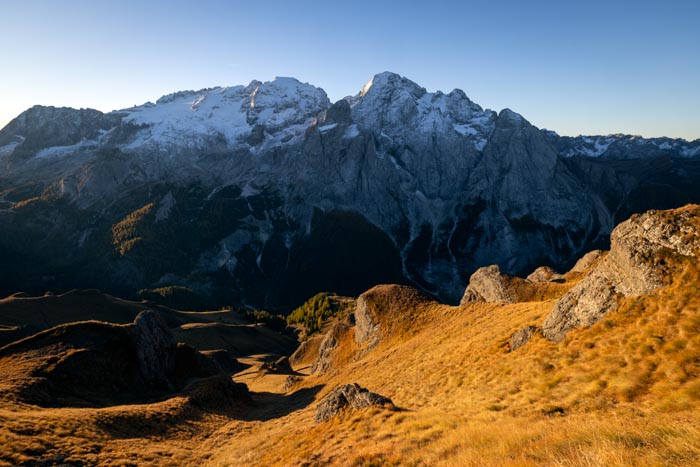
This relatively uncrowded route passes through a landscape that transitions from forest to open pastures dominated by the vertiginous walls of the "Queen of the Dolomites," which rise over 1,000 meters high.
Remarks
Parking: There is a large, free parking lot right in front of the Marmolada campground at Malga Ciapela, which is the starting point of the route.
Dining: three establishments are spaced along the route — the Malga Ciapela agriturismo (at the start of the route, about twenty minutes from the parking lot), Malga Ombretta (yogurts and cheeses produced on site), and Rifugio Falier (dining and overnight stays possible). All are open during the summer season, generally from mid-June to late September.
Description and difficulties of the hike
The trail is well-marked and easy to follow. You will follow CAI Trail 610 for almost the entire route. The terrain alternates between a forest track at the beginning of the hike and a classic mountain trail with no technical or exposed sections.
From the parking lot, cross the Marmolada campground at Malga Ciapela, then take the wide forest track that winds into a spruce and larch forest. The trail climbs steadily in switchbacks alongside the Pettorina torrent, whose roar accompanies you throughout the first part of the ascent. It is a pity that the trail does not get any closer; the vegetation almost completely blocks the view of these impressive waterfalls. Soon, you'll pass the junction to Forca Rossa on the left (CAI Trail 689, Alta Via 2), then continue to the right, above Malga Ciapela.
A final, slightly steeper section leads into Val Ombretta, where the scenery changes completely. The forest gives way to vast alpine meadows while the south face of Marmolada, a rock wall about a thousand meters high, rises to the right. In just a few minutes, you will reach Malga Ombretta (1,904 m), an ideal place to sample homemade dairy products. From there, an unnumbered trail climbs gently up the valley to a green plateau home to marmots that are very active in season. A final gentle ascent leads to Rifugio Falier, built in 1911, one of the first mountain huts in the Dolomites.
On the return trip, Trail 610 descends along the mountainside back to Malga Ombretta, forming a short loop. The rest of the route follows the same path as the outbound journey.
What you'll love
- The impressive south face of the Marmolada, which comes into view at the entrance to Val Ombretta and accompanies you throughout the second half of the route.
- The peaceful, uncrowded atmosphere of the valley.
- The Rifugio Falier, with its traditional stone architecture and white and blue shutters.
- The three dining spots along the route: Malga Ciapela Agriturismo, Malga Ombretta, and Rifugio Falier.
Hike technical sheet
➡️ Hiking parameters
➡️ Hiking parameters
➡️ Hiking parameters
Map and elevation profile of the hike
Slideshow


Nearby hikes

Forca Rossa and Rifugio Fuciade Hike
- Difficulty : Moderate
- Duration : 4 h 15
- Distance : 10.9 km
- Elevation gain : 680 m
Padon Ridge and Viel del Pan Loop Hike
- Difficulty : Easy
- Duration : 2 h 45
- Distance : 7.4 km
- Elevation gain : 420 m

Passo Pordoi to Lago di Fedaia via Viel del Pan Hike
- Difficulty : Moderate / Hard
- Duration : 5 h 30
- Distance : 15.3 km
- Elevation gain : 780 m

Piz Boè Hike
- Difficulty : Easy
- Duration : 2 h 45
- Distance : 6.3 km
- Elevation gain : 460 m
Map of the 13 closest hikes
Hikes to discover

Via Ferrata Ivano Dibona
- Hiking Difficulty : Hard
- Via Ferrata Difficulty : B (Moderatly difficult)
- Duration : 7 h
- Distance : 8.9 km
- Elevation gain : 1180 m

Via Ferrata Degli Alpini and Monte Lagazuoi
- Hiking Difficulty : Moderate
- Via Ferrata Difficulty : C (Difficult)
- Duration : 5 h
- Distance : 8 km
- Elevation gain : 830 m

Lago di Braies Loop
- Difficulty : Very easy
- Duration : 1 h 15
- Distance : 3.7 km
- Elevation gain : 90 m

Via Ferrata Ra Gusela
- Hiking Difficulty : Easy
- Via Ferrata Difficulty : A (Easy)
- Duration : 3 h 30
- Distance : 8 km
- Elevation gain : 610 m

Fanes Waterfalls Hike and Via Ferrata
- Hiking Difficulty : Moderate
- Via Ferrata Difficulty : A (Easy)
- Duration : 4 h 30
- Distance : 10 km
- Elevation gain : 560 m

Croda Fiscalina Loop via Rifugio Locatelli
- Difficulty : Hard
- Duration : 7 h 30
- Distance : 18.5 km
- Elevation gain : 1210 m