Brennisteinsalda Hike
Hike overview
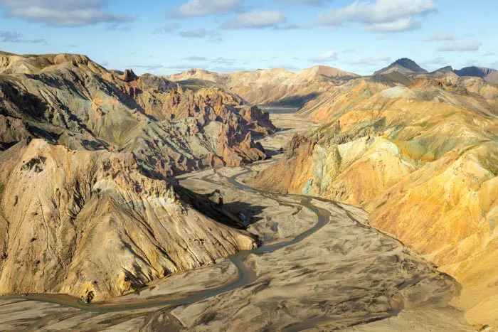
Discover Brennisteinsalda, a majestic 881-meter-tall volcano, which is part of the Torfajökull volcanic system in Landmannalaugar. Its name, meaning "wave of sulfur," refers to the solfatara (a type of volcanic fumarole) that has colored its slopes. It is one of the most photogenic and colorful mountains in Iceland. This hike is one of the most popular in the region for good reason—the landscape is stunning throughout the route.
Tip: If you have the time and energy, combine this hike with the ascent of Bláhnúkur for an even more memorable experience. See the Bláhnúkur and Brennisteinsalda hike page for more information.
Remarks
Getting to Landmannalaugar: The roads in the highlands are only open in the summer. Several bus companies provide connections to Reykjavik. If you prefer to drive, you will need a 4WD vehicle to travel on F-roads. There are three options available to you:
- The F208 road from the north: the easiest option, with no river crossings.
- The F225 road: more picturesque but requires crossing several shallow rivers.
- The F208 road from the south: crosses several medium-depth rivers.
See my dedicated page on driving in the Highlands for more information.
Parking: It is now necessary to reserve a parking space before your arrival.
Hiking in Landmannalaugar: Check out my Landmannalaugar guide to help you choose your hikes.
Difficulties of the hike
As with all hikes in Landmannalaugar, the trail is well-maintained and clearly marked. It is an easy route with no technical difficulties that will stay with you long after you've finished.
What you'll love
- The exceptional colorful spectacle: The red, yellow, and orange hues of the volcano create a striking contrast with the black lava fields.
- Exceptional panoramic views from the summit overlooking much of Landmannalaugar, the Laugahraun lava field, and the colorful surrounding mountains.
- Fascinating geological diversity: Cross the Laugahraun lava field, which has remarkable geological formations, and discover active solfatara and fumaroles on the slopes of Brennisteinsalda.
- Relaxing bath: Soak in the natural hot spring at Landmannalaugar to relax your muscles after a long day of hiking.
Hike technical sheet
➡️ Hiking parameters
➡️ Hiking parameters
➡️ Hiking parameters
Map and elevation profile of the hike
Slideshow


Nearby hikes

Bláhnúkur Hike
- Difficulty : Easy
- Duration : 2 h 30
- Distance : 6.3 km
- Elevation gain : 400 m

Bláhnúkur and Brennisteinsalda Hike
- Difficulty : Moderate
- Duration : 4 h
- Distance : 9.9 km
- Elevation gain : 620 m
Bláhnúkur, Skalli and Grænihryggur Circuit
- Difficulty : Very Hard
- Duration : 9 h
- Distance : 23.7 km
- Elevation gain : 1500 m

Landmannalaugar to Ljótipollur Hike
- Difficulty : Moderate
- Duration : 4 h 30
- Distance : 13 km
- Elevation gain : 330 m
Map of the 10 closest hikes
Hikes to discover
Let chance guide your steps: discover a random selection of the best hikes in Iceland.