Réttarfell Hike
Hike overview
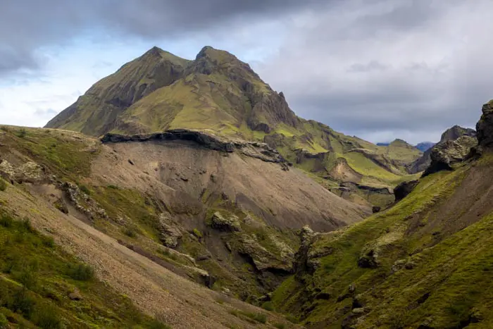
The hike up Réttarfell (also known as Vestrihattur) begins in Thórsmörk, Thor's Valley in English, named after the Norse god. Located between the ice caps of Mýrdalsjökull and Eyjafjallajökull in the highlands, this rugged area is a favorite spot among Icelanders and a paradise for hikers. Sheltered from Atlantic winds, the valley has a surprisingly mild summer climate, which promotes lush vegetation, including numerous birch forests.
This short but intense hike is rewarded with exceptional views of the Thórsmörk valley, the glaciers of Myrdalsjökull and Eyjafallajökull, and the magnificent Hvannárgil canyon.
Remarks
Getting to Thórsmörk: I strongly recommend taking one of the bus companies to reach the region. The F249 road to Thórsmörk has some of the most challenging river crossings in Iceland and should only be attempted by highly experienced drivers with suitable vehicles.
You can book tickets with the bus companies Icelandia and TREX.
Hiking in Thórsmörk: Check out my Thórsmörk hiking guide to help you choose your hikes.
Difficulties of the hike
Although it is short and on a clearly marked trail, this route is for experienced hikers. The descent from Réttarfell is very technical, with many vertiginous cliffside passages.
What you'll love
- Exceptional summit panorama: Spectacular 360° views of the Thórsmörk Valley, Mýrdalsjökull and Eyjafjallajökull glaciers, and Hvannárgil Canyon.
- The sense of adventure provided by this short but intense hike, which is ideal for a half-day of exploration.
- Unspoiled landscapes and a sense of solitude in this untouched natural environment, far from tourist crowds.
Hike technical sheet
➡️ Hiking parameters
➡️ Hiking parameters
➡️ Hiking parameters
Map and elevation profile of the hike
Slideshow


Nearby hikes

Móði and Magni Craters Hike
- Difficulty : Hard
- Duration : 7 h
- Distance : 16.2 km
- Elevation gain : 1100 m

Hvannárgil Hike
- Difficulty : Easy
- Duration : 2 h
- Distance : 4.9 km
- Elevation gain : 380 m

Tindfjöll Circuit Hike
- Difficulty : Moderate
- Duration : 3 h 30
- Distance : 8.8 km
- Elevation gain : 380 m
Rjúpnafell Hike
- Difficulty : Very Hard
- Duration : 6 h
- Distance : 14.3 km
- Elevation gain : 920 m
Map of the 10 closest hikes
Hikes to discover
Let chance guide your steps: discover a random selection of the best hikes in Iceland.